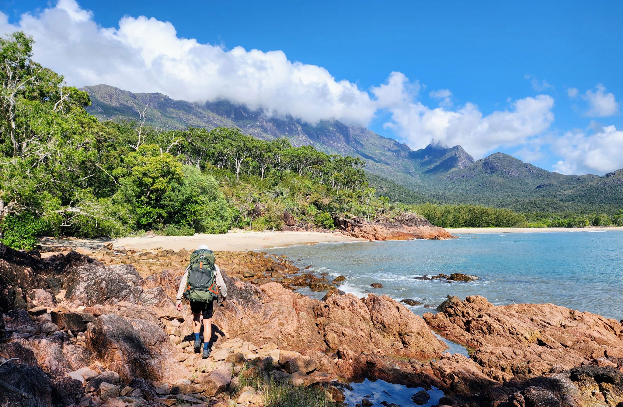
Thorsborne Trail
The 32km Thorsborne Trail, along Hinchinbrook Island's east coast. The trail is a remote and challenging walking experience, and in some areas, is rough and difficult to traverse.
Accessible by
- Boat
Camping area facilities
- Tent camping
- Walking
Always check
- Park alerts for the latest information on access, closures and conditions.
- Bureau of Meteorology weather forecasts.
- Current bushfire warnings and incidents and also fire bans and restrictions.
- Your camping permit is booked.
- Any park-specific camping information for
Thorsborne Trail.
- Visiting Thorsborne Trail safely for important safety information.
There are seven camping areas along the Thorsborne Trail. The camping areas are described here in a north to south order and all are on the eastern side of Hinchinbrook Island.
Camping permits are required and fees apply. Group bookings and mountain access approval must be obtained by emailing the Queensland Parks and Wildlife Service (QPWS) at qpws@des.qld.gov.au before going to the island. It is best to book well in advance. The trail is very popular and often fully booked during peak periods and school holidays. Camping bookings are not for the individual camping areas but for the Thorsborne Trail generally.
It is imperative that hiking details are left with a responsible contact person. This will assist in the event of an emergency situation or when hikers are overdue. The contact person must know:
- how hikers are accessing the island e.g. private vessel or water taxi
- the planned route
- when hikers are due to return
- the agreed time period after which the contact person will need to contact emergency services
- call Triple Zero (000) for all emergencies or if hikers do not return within set time period.
If no longer hiking the trail, ensure to cancel bookings by contacting us. Information on cancellations assists in emergencies such as cyclones and wildfires. Please ensure you supply relevant contact details when you book.
The fawn-footed melomys Melomys cervinipes and giant white-tailed rat Uromys caudimaculatus occur across the island. To avoid damage to packs and food supplies:
- Remove all food from packs at night.
- Keep cooking utensils and food covered and off the ground.
- Use pack racks - do not hang packs in trees.
Our precious Great Barrier Reef World Heritage islands are among the most pest-free islands in the world. They need your help to stay this way. Please Be pest-free! before your visit.
Park-specific conditions
- Open camp fires and cooking fires are not allowed.
Read more about staying safe and looking after the park.
Essentials to bring: read before you visit.
Nina Bay camping area

Nina Bay camping area by the beach.
Photo credit: © Queensland Government
Camping area features: under trees on and near the beach.
Location: this is the first camping area from the northern end of the Thorsborne Trail.
Access: the camping area can be reached on foot from the Thorsborne Trail.
Number of sites: sites are separately defined with the camping area.
Camp sites are suitable for: Thorsborne trail hikers only.
Camp site surface: sand and dirt.
Facilities: composting toilets, pack rack.
Open fires: prohibited.
Generators: not permitted.
Mobile phone coverage: no reception.
Little Ramsay Bay camping area

Little Ramsay Bay camping.
Photo credit: © Queensland Government
Camping area features: under trees on and near the beach.
Location: at the southern side of the lagoon area at Little Ramsay Bay. This is the second camping area from the northern end of the Thorsborne Trail.
Access: the camping area can be reached on foot from the Thorsborne Trail.
Number of sites: open area without separately defined sites.
Camp sites are suitable for: trail hikers only.
Camp site surface: sand and dirt.
Facilities: composting toilets, pack rack.
Open fires: prohibited.
Generators: not permitted.
Mobile phone coverage: no reception.
Banksia Bay camping area
Camping area features: under trees and in the open near the beach setting
Location: 300m off the main Thorsborne Trail, this small camping area is on the beach at Banksia Bay. It is the third camping area from the northern end of the Thorsborne Trail.
Access: the camping area can be reached on foot from the Thorsborne.
Number of sites: small site, open area without separately defined sites.
Camp sites are suitable for: Thorsborne trail hikers, boat-based and sea kayak camping also occurs at this location.
Camp site surface: sand and dirt.
Facilities: none.
Open fires: prohibited.
Generators: not permitted.
Mobile phone coverage: no reception.
Zoe Bay camping area

South Zoe Bay camping and day-use area.
Photo credit: © Queensland Government
Camping area features: under trees on and near the beach.
Location: at the southern end of Zoe Bay. This is the fourth camping area from the northern end of the Thorsborne Trail.
Access: the camping area can be reached on foot from the Thorsborne Trail or by boat.
Number of sites: sites are separately defined sites within the camping area.
Camp sites are suitable for: Thorsborne trail hikers. Boat-based camping and visitation by day user also occurs at this location.
Camp site surface: sand and dirt.
Facilities: composting toilets and picnic tables, pack racks.
Open fires: prohibited.
Generators: not permitted.
Mobile phone coverage: no reception.
Sunken Reef Bay
Camping area features: On beach foreshore. This camping area is exposed to the elements with minimal shade.
Location: On coast very steep 950m side-track off main trail. This is the fifth camping area from the northern end of the trail.
Access: the camping area can be reached on foot from the Thorsborne Trail.
Number of sites: open area without separately defined sites.
Camp sites are suitable for: Thorsborne trail hikers. Sea kayak camping also occurs at this location.
Camp site surface: sand.
Facilities: none.
Open fires: prohibited.
Generators: not permitted.
Mobile phone coverage: poor.
Mulligan Falls camping area

Camping at Mulligan Falls amongst the rainforest.
Photo credit: © Queensland Government
Camping area features: in the rainforest near Mulligan Falls.
Do not enter the restricted access area at the falls. Death and serious injuries have occurred when people have entered this area. Rock pavements, including those well back from the falls, are extremely slippery and dangerous.
Location: near the base of Mulligan Falls. This is the sixth camping area from the northern end of the Thorsborne Trail.
Access: the camping area can be reached on foot from the Thorsborne Trail.
Number of sites: sites are separately defined sites with the camping area.
Camp sites are suitable for: trail hikers only.
Camp site surface: dirt.
Facilities: composting toilets. Collect water from the creek at the base of the falls.
Open fires: prohibited.
Generators: not permitted.
Mobile phone coverage: poor.
George Point camping area

The camping area at George Point.
Photo credit: © Queensland Government
Camping area features: under trees on and near the beach.
Location: at the southern end of Mulligan Bay, this is the southern exit/entrance of the Thorsborne Trail.
Access: the camping area can be reached by boat and from the Thorsborne Trail.
Number of sites: sites are separately defined sites within the camping area.
Camp sites are suitable for: Thorsborne trail hikers. Boat-based and kayak camping also occurs at this location.
Camp site surface: sand and dirt.
Facilities: composting toilets and picnic table.
Open fires: prohibited.
Generators: not permitted.
Mobile phone coverage: poor.
Upcoming camping area availability
Visiting safely
For more safety information see Visiting Thorsborne Trail safely and camp with care.
- George Point camping area erosion 24 April 2024 to 24 April 2025