Check park alerts for the latest on access, closures and conditions, following recent severe weather events in Queensland. Rangers are working hard to safely reopen affected parks.
Visiting Springbrook safely
Queensland National Parks Booking System Update
The new Queensland National Parks Booking Service is live for bookings.
Customer account login
If you are making your first booking since 1 July 2024, a new customer account will be created automatically as part of your next booking. Please note your previous login credentials will no longer be valid.
Customers who have made a booking after 1 July 2024, please use your email address to reset your password to access your account.
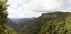
Looking towards the Gold Coast.
Photo credit: Maxime Coquard, Queensland Government
Getting there and getting around
Springbrook National Park is located about 100km south of Brisbane and comprises four sections on and around the plateau; Springbrook section extends along the crest of the plateau, Mount Cougal section to the south east and Natural Bridge and Numinbah sections to the west.
Springbrook section
From the Pacific Motorway, Springbrook plateau is 24km from Mudgeeraba or 36km from Nerang. Exit the Pacific Motorway at Mudgeeraba (exit 79 from the north, exit 80 from the south) and follow the Gold Coast–Springbrook Road. Alternatively, exit the Pacific Motorway at Nerang (exit 69) and follow the Nerang–Murwillumbah Road for 23km then take the Springbrook turn-off at Pine Creek Road. Both bitumen roads are steep, winding and narrow.
Note: There is no through-road access to New South Wales from the Springbrook plateau.
Important! For your safety, remain outside the Purling Brook Falls restricted access areas at the top (PDF, 89.1KB) and base (PDF, 89.1KB) of the waterfall—these areas are unstable and prone to rockfalls. Access to the restricted access areas indicated on the maps is prohibited at all times. Penalties apply.
Natural Bridge section
Exit the Pacific Motorway at Nerang (exit 69) and follow the Nerang–Murwillumbah Road for 38km, then turn left into the park entrance. An alternative scenic route is 42km via the Springbrook plateau from Mudgeeraba. From the Pacific Motorway take exit 80 from the south or exit 79 from the north and follow the Gold Coast–Springbrook Road to the plateau then turn right onto Pine Creek Road. Follow Pine Creek Road to the end and then turn left onto the Nerang–Murwillumbah Road. Natural Bridge can also be reached from Murwillumbah by following the Numinbah Road for 28km. The scenic access roads are winding and should be travelled with care.
Important! Cave Creek in the Natural Bridge section is a restricted access area. Swimming in the creek, including within the cave, and access to the creek bank is prohibited at all times. Penalties apply.
Mount Cougal section
Exit the Gold Coast Highway at either Duringan Street or Thrower Drive and follow the signs inland to Currumbin Creek Road (State route 95). Alternatively, exit the Pacific Motorway to head west on Stewart Road and turn left onto Currumbin Creek Road at the T-intersection. The Cougal Cascades car park and picnic area are at the end of Currumbin Creek Road approximately 18km from the Stewart Road intersection. Some roads can become flooded during times of heavy rain. Please check road conditions before travelling.
Numinbah section
Numinbah is 13km north of Natural Bridge section on Nerang–Murwillumbah Road. Leave the Pacific Motorway at Nerang (exit 69) and follow the Nerang–Murwillumbah Road for 25km. From the other direction on this route, this part of the park is 42km north-west of Murwillumbah. An alternative scenic route is 28km via the Springbrook plateau from Mudgeeraba. From the Pacific Motorway take exit 79 from the north or exit 80 from the south and follow the Gold Coast–Springbrook Road to the plateau. Turn right onto Pine Creek Road, follow it to the end and then turn left onto the Nerang–Murwillumbah Road. These scenic access roads are winding and should be travelled with care.
Wheelchair accessibility
Wheelchair access (with assistance) is possible at:
- Canyon lookout
- Mount Cougal section along the 800m bitumen Cascades walking track.
- Gauriemabah along the Buliya-buliya jagun (land of many little birds) boardwalk
- Gwongorella picnic area. Please use the Gwongorella picnic area map (PDF, 330.8KB) as a guide to facilities.

All creeks on Springbrook plateau become waterfalls! Stay safe and keep on the tracks.
Photo credit: Paul Candlin, Queensland Government

To protect the environment and yourself, stay on the walking tracks and behind the fences at Natural Bridge.
Photo credit: Dan Garnett, Queensland Government
Staying safe
Spinal cord injuries such as quadriplegia and paraplegia are some of the serious consequences of either jumping or diving into creeks. Drowning is the greatest threat to people who have injured their spines through jumping or diving into water. Take notice of the signs and remember: there is no cure for spinal cord injury—it’s with you for life.
Part of Cave Creek in the Natural Bridge section of the national park has been declared a restricted access area. Swimming in the creek and access to the creek bank is prohibited at all times. Penalties apply.
Purling Brook Falls is declared a restricted access area (PDF, 103.1KB) . Access is prohibited to the top (PDF, 103.1KB) and base (PDF, 89.1KB) of the waterfall at all times. Penalties apply.
Please observe and obey signs.
Cliffs and waterfalls are spectacular but dangerous features of the park. Be aware:
- All creeks on the plateau can rise abruptly and quickly become waterfalls.
- Rocks are slippery, even when they appear dry.
- Wandering off tracks could be fatal—keep to walking tracks and supervise children closely.
For your safety
- Be prepared, even on short walks, and judge your ability and conditions carefully before setting out. Do not expect to be warned of every possible danger.
- Choose walks that suit the capabilities of your entire group.
- Stay together and keep to the walking tracks. If you leave the track system that is maintained by park staff, you are putting your or your group's safety at risk.
- Always supervise children.
- Take care near cliff edges—they can be deceptive and are often closer than you think. Please keep away from the edge and supervise children at all times. Take extra care when using binoculars or cameras at these sites!
- Remain outside of all restricted access areas at Purling Brook Falls (both at the top and base of the falls) and Cave Creek .
- Never dive or jump into the water as it may be shallow or hide submerged objects.
- Do not cross creeks during floods or after heavy rain. Heavy rains can cause creeks to flash flood, where a huge volume of water can suddenly wash down the creeks and gullies.
- Wear a hat, sunscreen, comfortable clothes and sturdy shoes with good grip.
- Take a basic first-aid kit and manual.
- Always carry drinking water.
- Leave a copy of your bushwalking plans with a friend, relative or other reliable person. This person has responsibility for contacting police if you are overdue. Your plan should include:
- your name, address, number of people in your party, ages and any medical conditions
- vehicle registration, make, model, colour and parked location
- the route you are taking, expected times of departure and return.
- Remember that search and rescue is costly, endangers people's lives and can damage the environment.
- Walk with a recognised bushwalking club. This is a good way to gain experience.
- Walk with one or more friends. At least one member of each party should be a competent map-reader and bushwalker.
- Learn map and compass skills. There are online topographic maps that can be downloaded from websites such as QTopo. The graded walking tracks are covered in the following 1:25,000 map sheet:
- 9541-13—Springbrook
QTopo map tip!
If you are unfamiliar with QTopo there is a user guide, which includes a tutorial, to assist with the QTopo application and map features.
Thefts have occurred in this area. Car crime is a problem even here. Help us STOP this problem.
- Remove all valuables—this includes garage remotes.
- Lock your car.
- Remove your keys.
In an emergency
In case of accident or other emergency please:
- call Triple Zero (000)
- call 106 for a text-only message for deaf or speech- or hearing-impaired; callers
- advise the nature of the emergency and your location
- stay on the phone until you are told to hang up.
The nearest public hospitals are at Southport and Robina on the Gold Coast. Mobile phone coverage may not be reliable. You will usually receive a signal wherever you can see the Gold Coast.
For more information, please read the guidelines on safety in parks and forests.

Wear sensible footwear as tracks can become wet and slippery, even when they appear dry.
Photo credit: Adam Creed © Queensland Government

Be well prepared for your visit.
Photo credit: Adam Creed, Queensland Government

After significant rainfall, walking tracks may be closed for public safety. Please check the Park alerts before you visit. This is Purling Brook Falls circuit in flood after exTropical Cyclone Debbie, 2017.
Photo credit: Queensland Government

Purling Brook Falls circuit after extensive repairs from the 2017 floods.
Photo credit: Melissa Whitby, Queensland Government
Before you visit
Be prepared for your visit to ensure you have a safe and enjoyable time. Please note: mobile phone reception may be unreliable in the park.
Essentials to bring
Be prepared and use sound judgment while visiting and walking in Springbrook National Park.
- Carry sufficient food and water and a torch.
- Wear a hat and apply sunscreen to prevent sunburn.
- Wear sensible footwear—boots or strong shoes, warm and protective wet weather clothing—weather conditions can be changeable.
- Always pack a first-aid kit and first-aid manual. Learn first-aid procedures.
- Rubbish bins are not provided. Please bring rubbish bags, and take all recyclables and rubbish with you when you leave.
- Bring drinking water and pack sterilisation tablets or a fuel stove to treat/boil creek water before drinking.
- Bring your camera and binoculars for viewing wildlife. A torch, preferably with a red filter to protect animals' eyes, is useful for spotlighting at night.
Springbrook plateau can be cool and rainy at all times of the year so carry a raincoat and warm clothing.
Opening hours
Springbrook National Park is open 24 hours a day. For your safety, walk in daylight hours only, unless viewing the glow-worms at Natural Bridge. For glow-worm night tours at Natural Bridge, see the tourist information links. If you intend viewing the glow-worms at night, please ensure you follow the guidelines in staying safe.
Permits and fees
To camp in Springbrook National Park, a camping permit is required and fees apply. Try to book and pay six to eight weeks in advance for public holidays. Bookings are accepted only when accompanied by the appropriate fee. If you wish to extend your stay, you must re-register. A tag with your booking number must be displayed at your camp site. Remember: camping fees must be lodged before camping overnight.
- Find out more about camping in Springbrook National Park.
- Book your camp site online.
- If you cannot book online, see camping bookings for other options.
If you are planning to conduct a non-commercial organised activity in the park, you may need an organised event permit.
Pets
Domestic animals are not permitted in Springbrook National Park. On the spot fines apply for people caught with domestic animals within the park.
Climate and weather
At 900m above sea level, Springbrook plateau can be quite cool even in summer—the plateau is generally cooler than the adjacent lowland. The area can receive more than 3,000mm of rain a year, most of which falls between December and March. It is advisable to carry a raincoat and warm clothing at all times of the year.
Winters are usually cold with frosty nights, temperatures can drop to a minimum of -4°C. Summers are warm to hot, especially on the exposed ridges, reaching 30°C or above.
Natural Bridge and Mount Cougal are not so wet or cold. Natural Bridge's annual rainfall of 2,500mm falls during the hot, humid summer (maximum 38°C), while the winters are often clear and crisp (minimum 4°C). During summer's long, hot days Mount Cougal usually experiences afternoon thunderstorms (maximum 37°C). Winter mornings at the head of the valley can be brisk with occasional frosts (minimum 2°C).
Numinbah is slightly warmer than Natural Bridge; summers are hot and humid (maximum 36°C) while winters are clear and crisp with potential for frosts (minimum 4°C).
Weather forecasts are available from the Bureau of Meteorology.
Be aware! During extreme weather events such as heavy rain and high winds, access to areas of the park may be closed. Please ensure you check park alerts before you visit this park.
Fuel and supplies
No fuel is available near the national park. Public telephones, meals and light refreshments are available on Springbrook plateau. A public telephone and cafe are available along the Nerang-Murwillumbah Road, 1km north of Natural Bridge section. A public telephone and cafe are located near the Numinbah Hall. A public telephone and cafe are located east of Mount Cougal along the Currumbin Creek Road. For more information see the tourism information links.
- Emergent works and temporary closure - Settlement Day-use Area 28 April to 2 May 2025
- Severe Weather damage - Springbrook National Park 18 March to 23 May 2025
- Emergent maintenance - Toilets closed at Tallanbana 10 January to 30 June 2025