Check park alerts for the latest on access, closures and conditions, following recent severe weather events in Queensland. Rangers are working hard to safely reopen affected parks.
Walking
Queensland National Parks Booking System Update
The new Queensland National Parks Booking Service is live for bookings.
Customer account login
If you are making your first booking since 1 July 2024, a new customer account will be created automatically as part of your next booking. Please note your previous login credentials will no longer be valid.
Customers who have made a booking after 1 July 2024, please use your email address to reset your password to access your account.
Walking options
The Gold Coast Hinterland Great Walk traverses 54km linking Lamington and Springbrook national parks via the Numinbah Valley. The entire walk takes three days to complete.
The on-screen, low resolution Gold Coast Hinterland Great Walk map can be used as a guide to plan your walk—but do not use it while walking. Use topographic maps that can purchased or downloaded free from websites such as QTopo to navigate on your walk.
The graded walking tracks are covered in the following QTopo QldMapSheets at 1:25,000:
- 9541-42 Beechmont
- 9541-31 Tyalgum
- 9541-13 Springbrook
QTopo map tip! If you are unfamiliar with QTopo, there is a user guide that includes a tutorial to assist with the QTopo application and map features.
Both Lamington and Springbrook national parks provide a number of short and long-walk options that can be added to the Great Walk. Please ensure you have a copy of the walking track maps for Springbrook and for Lamington—the Binna Burra section map and Green Mountains section map .
For more information, see Lamington National Park and Springbrook National Park.

Binna Burra to Woonoongoora walkers' camp.
Photo credit: Robert Ashdown © Queensland Government
Additional track specific information
- Junctions are sign-posted but the track may be extensively overgrown; hazards such as fallen trees and rockfalls likely to be present.
- Track is variable in width; muddy sections, steep grades and steps may be encountered.
- Caution is needed at creek crossings, cliff edges and naturally-occurring lookouts.
The Great Walk
Allow three days to complete the 54km Gold Coast Hinterland Great Walk. It is recommended that you walk west to east, commencing the walk from Lamington National Park—Green Mountains section (O’Reilly) and ending at The Settlement camping area in Springbrook National Park.
- Green Mountains (O'Reilly) to Binna Burra
- Binna Burra to Woonoongoora walkers' camp
- Woonoongoora walkers' camp to The Settlement camping area
Green Mountains (O’Reilly) to Binna Burra
Distance: 21.4km one way
Time: Allow about 7hr
Details: Begin your walk from Green Mountains section of Lamington National Park along the well-known Border Track that links the Green Mountains section of the national park to the Binna Burra section.
The Border Track traverses some of the highest remaining basalt lavas from the Tweed Volcano. With increasing elevation, it passes from warm and cool subtropical rainforests into warm and cool temperate rainforests. Lookouts along the Border Track are on the rim of the Tweed Valley erosion caldera and on a clear day you can see Wollumbin (Mount Warning), the distant Nightcap Range, the Lamington wilderness area and the Tweed Range. The cultural name Wollumbin (pronounced Wool-oom-bin) means 'cloud catcher' to some Aboriginal people.
Binna Burra to Woonoongoora walkers’ camp
Distance: 23.6km one way
Time: Allow about 6 to 8hr
Details: Begin at the Ships Stern track and Lower Bellbird circuit entrance, below the Binna Burra campground. Follow the clearly marked Ships Stern circuit for 3.7km, descending through cliff lines of rhyolite and tuff (volcanic ash) and into Kurraragin Valley where the track passes fine stands of piccabeen palm Archontophoenix cunninghamii, large red cedar Toona ciliata and majestic flooded gum Eucalyptus grandis.
Branching left on to the Lower Bellbird circuit, the track passes through a patch of dry rainforest, regarded as an example of the rise of the ‘dry-adapted’ flora now widespread in Australia, and then follows the base of a spectacular rhyolite cliff line to reach the Great Walk track junction.
The track descends steeply for 2.5km then turns east to cross Nixon Creek. Watch as the intrusive plug of Egg Rock ('Kurraragin', meaning 'very tall') seems to rise sharply through the trees. Egg Rock (Kurraragin) is identified as a significant First Nations people's area under the Aboriginal Cultural Heritage Act 2003 and is declared a restricted access area to protect cultural heritage values—unauthorised entry is prohibited. Please respect the cultural significance of this landmark and remain on the Great Walk. The track then heads north-east for a further 2.4km through selectively-cleared woodland before reaching the Nerang–Murwillumbah Road in Numinbah Valley.
Parts of this section of the Great Walk follows an easement through a private grazing property and the Numinbah Correctional Centre. Please respect private property by staying on track and observing all signs.
The Great Walk follows the Nerang–Murwillumbah Road for 3.4km. This can be a busy road—please observe road signs, cross where totem signs indicate and maintain a safe distance from the road. Keep to the Great Walk track, which is identified by directional signs, rather than walking on the road edge. You can continue to the Woonoongoora walkers’ camp or end your walk here. Please organise transport before you leave Lamington National Park as there is no public transport from this point.
A steep 1.6km climb to Chesters Road begins shortly after leaving Numinbah township. This small section of the walk forms part of the Numinbah section of Springbrook National Park’s horse trails network. Horse-riders have right-of-way. For more information about horseriding in Numinbah section of Springbrook National Park please visit South East Queensland Horseriding Trails Network or QPWS horseriding.
Once on Chesters Road, follow it to the top. After crossing the stile to your left, descend into the Waterfall Creek valley—a great amphitheatre walled by spectacular white cliffs. The cliffs are the result of a thick rhyolite flow from the ancient volcano. Follow the road down about 1km through the City of Gold Coast Council’s Springbrook Conservation Area, and then follow markers as the route skirts previously-cleared, grassy areas. The track crosses Waterfall Creek before meandering up a slope to the walkers' camp.
Woonoongoora walkers’ camp to The Settlement camping area
Distance: 9km one way
Time: Allow about 4 to 5hr
Details: From your camp site at Woonoongoora, continue uphill for 1.9km to Apple Tree Park located on the Springbrook plateau. The first 1.5km of track, which climbs the rhyolite cliff line, is steep and arduous with over 900 steps to negotiate before reaching the plateau. The track climbs through a grove of cycads that cling to the steep slopes of the ridge. These are an ancient plant form—ancestors of the living cycads predating the dinosaurs. Fossil records indicate that the ancestral plants existed almost 300 million years ago. Despite the very high rainfall, the summit of the plateau supports only tall eucalypt forest primarily because of the poorer rhyolite soils.
From Apple Tree Park, cross Springbrook Road and follow the Great Walk markers along the powerline easement, through the gate, and drop down into the catchment of the Little Nerang Dam. This section of the track can be wet and slippery. Care should be taken when crossing Little Nerang Creek. Once across the creek, turn right and follow the track along the west branch of Little Nerang Creek up the side of a narrow gorge with pools and cascades cut into older rocks from beneath the volcano. After 1km the track emerges at a basalt slab above Warringa Pool—a great place to stop and take in the sounds of the rainforest.
Caution: the Warringa Pool section may be closed during floods or extreme fire danger. Please ensure you check the Park alerts before you set out.
The track continues on the other side of the creek to Purling Brook Falls, where a massive cliff of cream-coloured rhyolite, 100m high, looms over a deep gorge of black basalt. After crossing the suspension bridge, a steady climb brings you back to the top of the plateau. Just before crossing the top of Purling Brook, the track branches left to The Settlement camping area.
For your safety remain outside the Purling Brook Falls restricted access area —this area is prone to rockfalls.
Note: if doing this section in reverse, you will need to reinterpret the track notes carefully and keep a close eye out for track markers.
Walk safely
Sections of the Gold Coast Hinterland Great Walk are remote and isolated. Accidents have happened, even to experienced bushwalkers. You must be well prepared and responsible for your own safety, even on short walks.

Never walk alone—small groups of about four are ideal.
Photo credit: Adam Creed © Queensland Government

Wear sensible footwear as tracks can become wet and slippery.
Photo credit: Adam Creed © Queensland Government
General safety guidelines
Always check
- Park alerts for the latest information on access, closures and conditions.
- Bureau of Meteorology weather forecasts.
- Current bushfire warnings and incidents and also fire bans and restrictions.
- Your camping permit is booked.
- Any park-specific camping information for Gold Coast Hinterland Great Walk.
- Visiting Gold Coast Hinterland Great Walk safely for important safety information.
Be prepared
- Before you start your walk, always tell a responsible person where you are going and when you expect to return. Have an emergency plan in place if you fail to contact them by an agreed time.
- Never walk alone—small groups of about four are ideal. Ensure experienced adults accompany children.
- Carry topographic maps and a compass—know how to use them.
- Where there is no mobile coverage, you will not be able to reach the Emergency Call Service via a mobile phone. Consider taking a satellite phone, personal locator beacon (PLB) or another form of communication. Make sure you pack extra batteries.
- We highly recommend you visit the Triple Zero website before visiting the park and download the Triple Zero emergency app to help identify your location.
Stay safe!
- Stay on the designated walking track.
- Know your location at all times.
- Check your map regularly to mark your progress against features on the track.
- Plan to reach and set up camp well before dark and before bad weather sets in. Don’t walk at night.
- Keep your group together. Know your group’s limitations and change your plans as necessary.
- If someone becomes ill or difficult weather sets in, make camp and wait for conditions to improve or help to arrive.
- Treat tank or creek water before drinking.
In an emergency
- If you are lost, stay where you are and call for help.
- For all emergencies, call Triple Zero (000).
- Call 106 for deaf or speech or hearing-impaired callers.
- Advise the nature of the emergency and your location.
- Stay on the phone until you are told to hang up.
- Conserve mobile battery power but do not turn off or disable incoming calls or messages.
- If communication by phone is not possible—activate your emergency beacon device.
For more information, please read the guidelines on safety in parks and forests.
Fire safety
Bushfires can pose a threat to walkers. They can occur without warning so be aware of and prepared for the dangers.
- If there is a bushfire, follow the track to the nearest road, firebreak or waterway for refuge.
- Burnt ground, large logs or a ditch can also provide protection.
- Avoid areas of heavy fuel, such as deep leaf litter, and stay low to the ground where the air is coolest and contains the least smoke.
- In extreme conditions, the walking track may be closed for your safety. Please observe all signs.
- For emergency evacuations, a helicopter landing area is located on the City of Gold Coast Council Springbrook Conservation Area, adjacent the Woonoongoora walkers’ camp.
Rangers carry out planned hazard reduction burning so check park alerts for updates on scheduled burning before you go.
If you see a fire, please phone Triple Zero (000) and speak to the fire service as soon as possible.
Flood safety
- Do not cross creeks during floods or after heavy rain.
- If caught during a flash flood, stay on higher ground and wait until the waters have receded.
- Continue your walk only when you can cross the creeks safely.
- In extreme wet conditions, the walking track will be closed for your safety. Please observe all signs.
For more information, please read the guidelines on safety in parks and forests.
Road safety
Sections of the Great Walk use existing road systems around Springbrook and cross the Nerang–Murwillumbah Road. Normal road rules apply. Follow road signs and cross with care at designated points along the roads.
For more information watch the Creek and road crossing safety web clip.
For your safety
Remain outside the Purling Brook Falls restricted access area —this area is prone to rockfalls.
Walk softly
Feel privileged—you are visiting an area recognised as one of the world's most outstanding and valuable places. Lamington and Springbrook national parks are part of the Gondwana Rainforests of Australia World Heritage Area. With pride, we protect and present this heritage—the world's heritage. Help ensure that we can all enjoy this wonderful area—tread softly and leave no trace!

A zip-lock bag is ideal for carrying out all food scraps and rubbish.
Photo credit: Adam Creed © Queensland Government
Don't let your walk destroy the forest; stop the spread of pathogens. Clean all camping gear and footwear before leaving home.
Photo credit: Robert Ashdown © Queensland Government

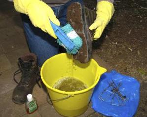
Please clean your boots at the pathogen control stations when entering and leaving the tracks.
Photo credit: Sergio Norambuena © Queensland Government
Camping
- Only use existing sites at walkers’ camps.
- Do not dig trenches or flatten or break any vegetation.
- Leave your site in the same or better condition than when you found it so others may enjoy the Great Walk too.
- Check your site thoroughly before leaving to ensure nothing is left behind.
Rubbish
- Reduce your rubbish by bringing as little packaging as possible. There are no rubbish bins on the Great Walk.
- All rubbish (including food scraps and bagged sanitary products) must be carried out.
- You can help the park by bringing out any other rubbish you find.
- Carry a small rubbish bag so that even tiny scraps of tin foil, sweet wrappers and cigarette butts can be carried out.
For more information watch the Rubbish: take it home web clip.
Use fuel stoves only
- No open fires are permitted along the Great Walk.
- Carry fuel stoves for cooking. Test equipment before you go and never cook in your tent.
- Do not leave stoves unattended when lit.
For more information watch the Fire and fuel stoves web clip.
Toilets
- Use toilets where provided.
- Where there are no toilets, bury human waste and toilet paper at least 100m from camp sites, tracks and waterways, and about 15 to 20cm deep.
- Take all sanitary items with you—they do not decompose. Clip seal bags are handy storage until you can dispose of the waste responsibly.
- Use a human waste disposal kit and take it out with you when you have completed your walk. Kits are available from some camping stores. Please follow manufacturer’s directions on the packet and dispose of waste responsibly.
For more information watch the Bush toileting and washing web clip.
Pathogen control
Don’t let your walk destroy the forest—stop the spread of phytophthora (a root fungus that causes dieback in trees) and other pathogens such as myrtle rust and amphibian chytrid fungus.
- Please clean and disinfect your footwear and camping equipment either at home using a disinfectant or before starting your walk. Watch the Stop the spread of weeds and pathogens web clip for more information.
- Keep to designated roads and walking tracks at all times.
- Start and finish your bushwalk with clean footwear, clothes and camping gear by removing soil from footwear, camping spade or trowel and tent pegs before leaving an area, and keep all gear as clean and free from soil as possible during the walk.
Pathogen control stations have been installed throughout the Great Walk. Please follow the instructions to prevent the spread of pathogens into the national parks and surrounding forests.
Use pathogen control stations located throughout the Great Walk.
Be frog friendly
- Please do not disturb, handle or remove frogs, their eggs or tadpoles.
- Do not use or discard soap, detergent, shampoo, sunscreen, insect repellent or any other potential pollutant in creeks or along the banks.
- Keep to walking tracks and when the track traverses a creek, cross directly where the track enters and exits the creek.
- Please do not disturb or remove rocks or trample vegetation in or directly adjacent to creeks.
See the guidelines on caring for parks for more information about protecting our environment and heritage in parks.
- Severe Weather Damage - Lamington National Park 14 March to 23 May 2025
- Severe Weather damage - Springbrook National Park 18 March to 23 May 2025
- Temporary walking track closure - Lower Bellbird track. 8 January 2024 to 2 May 2025