Discover remote gorges, sheltered pockets of subtropical rainforest, expanses of eucalypt woodland and spectacular views to Moreton Bay, all within 1.5hr drive of Brisbane.
D'Aguilar National Park totals approximately 40,000ha, protecting the core of the D'Aguilar Range’s vast bushland area.
Location
Between 12km and 35km north-west of Brisbane's city centre
Accessible by
- Conventional vehicle
- 4WD
Park facilities
- Barbecue (wood/fuel/coin)
- Campfires allowed (conditions apply)
- Information centre
- Lookout
- Park office
- Picnic tables (some sheltered)
- Toilets
- Wheelchair access (may require assistance)
- Tent camping
- Camper trailer camping
- Cycling
- Hiking
- Horseriding
- Scenic drive
- Trail bike riding
- Walking
-
![Photo of the camp fire places provided.]() Sit around the camp fire places provided and look for nocturnal wildlife.
Photo credit: Tomek Z Genek © Queensland Government
Sit around the camp fire places provided and look for nocturnal wildlife.
Photo credit: Tomek Z Genek © Queensland Government
-
![Photo of the camp fire places provided at Archer camping area.]() Enjoy the camp fire places provided at Archer camping area.
Photo credit: Tomek Z Genek © Queensland Government
Enjoy the camp fire places provided at Archer camping area.
Photo credit: Tomek Z Genek © Queensland Government
-
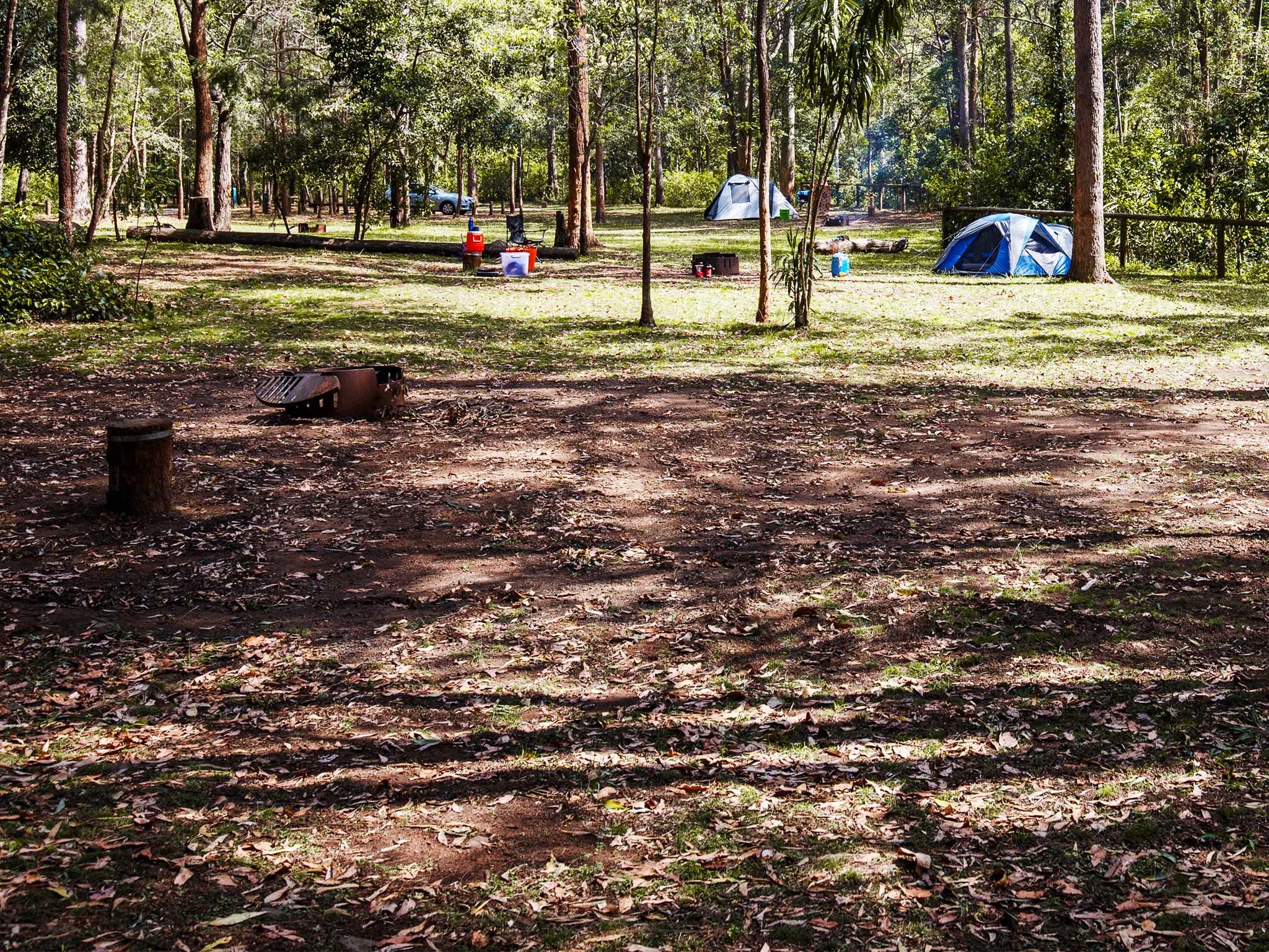
![Enjoy camping beneath spotted gums, ironbarks and grey gums.]() Enjoy camping beneath spotted gums, ironbarks and grey gums.
Photo credit: Diana Hughes © Queensland Government
Enjoy camping beneath spotted gums, ironbarks and grey gums.
Photo credit: Diana Hughes © Queensland Government
-
![A shelter shed and water tank mark the location of Light Line Road bush camp.]() A shelter shed and water tank mark the location of Light Line Road bush camp.
Photo credit: © Sue Gregory
A shelter shed and water tank mark the location of Light Line Road bush camp.
Photo credit: © Sue Gregory
-
![Feel like you're in the middle of nowhere.]() Feel like you're in the middle of nowhere.
Photo credit: Diana Hughes © Queensland Government
Feel like you're in the middle of nowhere.
Photo credit: Diana Hughes © Queensland Government
-
![There are awesome views on the way to England Creek Road bush camp.]() There are awesome views on the way to England Creek Road bush camp.
Photo credit: Diana Hughes © Queensland Government
There are awesome views on the way to England Creek Road bush camp.
Photo credit: Diana Hughes © Queensland Government
-
![Northbrook remote bush camp has sensational views from a high ridge top.]() Northbrook remote bush camp has sensational views from a high ridge top.
Photo credit: Diana Hughes © Queensland Government
Northbrook remote bush camp has sensational views from a high ridge top.
Photo credit: Diana Hughes © Queensland Government
-
![You'll need to navigate unmarked trails in steep terrain to get to South Kobble remote bush camp.]() You'll need to navigate unmarked trails in steep terrain to get to South Kobble remote bush camp.
Photo credit: Andrew Kingston © Queensland Government
You'll need to navigate unmarked trails in steep terrain to get to South Kobble remote bush camp.
Photo credit: Andrew Kingston © Queensland Government
-
![It's a steep, uphill hike to Middle Kobble bush camp.]() It's a steep, uphill hike to Middle Kobble bush camp.
Photo credit: Andrew Kingston © Queensland Government
It's a steep, uphill hike to Middle Kobble bush camp.
Photo credit: Andrew Kingston © Queensland Government
-
![Camp in a remote forest pocket of D'Aguilar National Park.]() Camp in a remote forest pocket of D'Aguilar National Park.
Photo credit: Andrew Kingston © Queensland Government
Camp in a remote forest pocket of D'Aguilar National Park.
Photo credit: Andrew Kingston © Queensland Government
-
![Get on your trail bike and explore the extensive road network in the northern section of the park.]() Get on your trail bike and explore the extensive road network in the northern section of the park.
Photo credit: Maxime Coquard © Queensland Government
Get on your trail bike and explore the extensive road network in the northern section of the park.
Photo credit: Maxime Coquard © Queensland Government
-
![A leisurely ride along the horseriding trails is a great way to experience the park.]() A leisurely ride along the horseriding trails is a great way to experience the park.
Photo credit: Maxime Coquard © Queensland Government
A leisurely ride along the horseriding trails is a great way to experience the park.
Photo credit: Maxime Coquard © Queensland Government
-
![Mountain bike ride on a network of shared trails in the southern section of D'Aguilar National Park.]() Mountain bike ride on a network of shared trails in the southern section of D'Aguilar National Park.
Photo credit: Maxime Coquard © Queensland Government
Mountain bike ride on a network of shared trails in the southern section of D'Aguilar National Park.
Photo credit: Maxime Coquard © Queensland Government
-
![Take the time to stop and enjoy the views.]() Take the time to stop and enjoy the views.
Photo credit: © Jen Bartlett
Take the time to stop and enjoy the views.
Photo credit: © Jen Bartlett
-
![Photo of a giant brush box tree.]() Discover remnants of a giant brush box tree.
Photo credit: © Queensland Government
Discover remnants of a giant brush box tree.
Photo credit: © Queensland Government
-
![Photo of the mountains and trees in the southern section of D'Aguilar National Park.]() Walk or ride the mountainous loop through the southern section of D'Aguilar National Park.
Photo credit: Diana Hughes © Queensland Government
Walk or ride the mountainous loop through the southern section of D'Aguilar National Park.
Photo credit: Diana Hughes © Queensland Government
-
![Take in expansive views through the trees.]() Take in expansive views through the trees.
Photo credit: Diana Hughes © Queensland Government
Take in expansive views through the trees.
Photo credit: Diana Hughes © Queensland Government
-
![The Cabbage Tree Range loop has gorgeous views through the trees.]() The Cabbage Tree Range loop has gorgeous views through the trees.
Photo credit: © Sue Gregory
The Cabbage Tree Range loop has gorgeous views through the trees.
Photo credit: © Sue Gregory
-
![Wander through a patch of open forest on the Cypress Grove track.]() Wander through a patch of open forest on the Cypress Grove track.
Photo credit: © Queensland Government
Wander through a patch of open forest on the Cypress Grove track.
Photo credit: © Queensland Government
-
![Look up into the forest canopy to see beautiful epiphytes along the Egernia circuit.]() Look up into the forest canopy to see beautiful epiphytes along the Egernia circuit.
Photo credit: © Queensland Government
Look up into the forest canopy to see beautiful epiphytes along the Egernia circuit.
Photo credit: © Queensland Government
-
![The Falls lookout track is an easy 400m walk.]() The Falls lookout track is an easy 400m walk.
Photo credit: Tomek Z Genek © Queensland Government
The Falls lookout track is an easy 400m walk.
Photo credit: Tomek Z Genek © Queensland Government
-
![Photo of wedge-tailed eagles which occasionally soar over the Golden Boulder track—remember to look up.]() Wedge-tailed eagles occasionally soar over the Golden Boulder track—remember to look up.
Photo credit: © Queensland Government
Wedge-tailed eagles occasionally soar over the Golden Boulder track—remember to look up.
Photo credit: © Queensland Government
-
![The Greenes Falls track leads through rainforest to a lookout above the falls.]() The Greenes Falls track leads through rainforest to a lookout above the falls.
Photo credit: Maxime Coquard © Queensland Government
The Greenes Falls track leads through rainforest to a lookout above the falls.
Photo credit: Maxime Coquard © Queensland Government
-
![Photo of dragonflies skimming the water’s surface of Neurum Creek.]() Watch dragonflies skim the water’s surface of Neurum Creek.
Photo credit: Tomek Z Genek © Queensland Government
Watch dragonflies skim the water’s surface of Neurum Creek.
Photo credit: Tomek Z Genek © Queensland Government
-
![Stop at the Mount Nebo lookout for spectacular views over the Samford Valley.]() Stop at the Mount Nebo lookout for spectacular views over the Samford Valley.
Photo credit: Diana Hughes © Queensland Government
Stop at the Mount Nebo lookout for spectacular views over the Samford Valley.
Photo credit: Diana Hughes © Queensland Government
-
![The Mount Mee forest drive is a full-day 4WD adventure!]() The Mount Mee forest drive is a full-day 4WD adventure!
Photo credit: Maxime Coquard © Queensland Government
The Mount Mee forest drive is a full-day 4WD adventure!
Photo credit: Maxime Coquard © Queensland Government
-
![Photo of slender piccabeen palms and ancient Sydney blue gums.]() Meander amongst slender piccabeen palms and ancient Sydney blue gums.
Photo credit: © Queensland Government
Meander amongst slender piccabeen palms and ancient Sydney blue gums.
Photo credit: © Queensland Government
-
![Stroll through palms, ferns and yellow carabeen trees.]() Stroll through palms, ferns and yellow carabeen trees.
Photo credit: B Hicks © Queensland Government
Stroll through palms, ferns and yellow carabeen trees.
Photo credit: B Hicks © Queensland Government
-
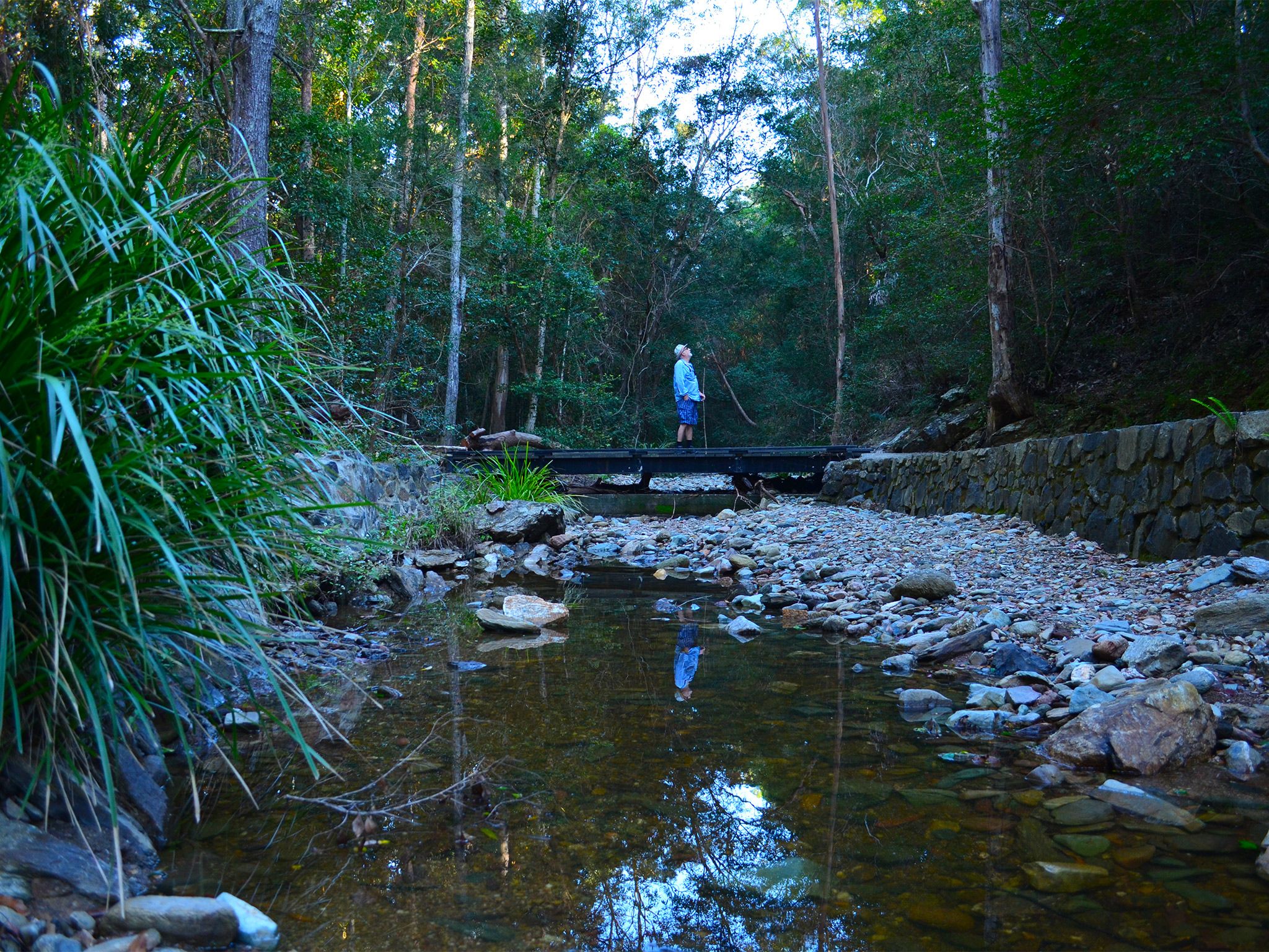
![Dip into cool subtropical rainforest with trickling creeks and lush vegetation.]() Dip into cool subtropical rainforest with trickling creeks and lush vegetation.
Photo credit: Maxime Coquard © Queensland Government
Dip into cool subtropical rainforest with trickling creeks and lush vegetation.
Photo credit: Maxime Coquard © Queensland Government
-
![Drive to the highest point of the range.]() Drive to the highest point of the range.
Photo credit: Tomek Z Genek © Queensland Government
Drive to the highest point of the range.
Photo credit: Tomek Z Genek © Queensland Government
-
![Marvel at views stretching over Somerset Dam and Lake Wivenhoe.]() Marvel at views stretching over Somerset Dam and Lake Wivenhoe.
Photo credit: Tomek Z Genek © Queensland Government
Marvel at views stretching over Somerset Dam and Lake Wivenhoe.
Photo credit: Tomek Z Genek © Queensland Government
-
![Climb steep and forested ridges to views of Enoggera Reservoir.]() Climb steep and forested ridges to views of Enoggera Reservoir.
Photo credit: © Sue Gregory
Climb steep and forested ridges to views of Enoggera Reservoir.
Photo credit: © Sue Gregory
-
![See moss-covered trees and boulders in cool subtropical rainforest.]() See moss-covered trees and boulders in cool subtropical rainforest.
Photo credit: Cameron Semple © High and Wide
See moss-covered trees and boulders in cool subtropical rainforest.
Photo credit: Cameron Semple © High and Wide
-
![Lomandras line Cedar Creek on the Turrbal circuit.]() Lomandras line Cedar Creek on the Turrbal circuit.
Photo credit: © Jen Bartlett
Lomandras line Cedar Creek on the Turrbal circuit.
Photo credit: © Jen Bartlett
-
![Photo of a 4WD driving on the Western Escarpment forest drive.]() For a scenic 4WD adventure with sensational views, explore the Western Escarpment forest drive.
Photo credit: © Jennifer Allan
For a scenic 4WD adventure with sensational views, explore the Western Escarpment forest drive.
Photo credit: © Jennifer Allan
-
![Walk to the lookout along the Western Window track for awe-inspiring views to the west.]() Walk to the lookout along the Western Window track for awe-inspiring views to the west.
Photo credit: Diana Hughes © Queensland Government
Walk to the lookout along the Western Window track for awe-inspiring views to the west.
Photo credit: Diana Hughes © Queensland Government
-
![Take a walk through some of the park's most beautiful subtropical rainforest.]() Take a walk through some of the park's most beautiful subtropical rainforest.
Photo credit: © Queensland Government
Take a walk through some of the park's most beautiful subtropical rainforest.
Photo credit: © Queensland Government
-
![Photo of Bellbird Grove day-use area which has great facilities for a picnic and barbeque.]() Bellbird Grove day-use area has great facilities for a picnic and barbeque.
Photo credit: Andrew Chisholm © Queensland Government
Bellbird Grove day-use area has great facilities for a picnic and barbeque.
Photo credit: Andrew Chisholm © Queensland Government
-
![A short track leads from the Broadwater day-use area to a waterhole on Neurum Creek.]() A short track leads from the Broadwater day-use area to a waterhole on Neurum Creek.
Photo credit: Tomek Z Genek © Queensland Government
A short track leads from the Broadwater day-use area to a waterhole on Neurum Creek.
Photo credit: Tomek Z Genek © Queensland Government
-
![Photo of the amazing views of Moreton Bay from the north-facing lookout.]() Camp Mountain has amazing views of Moreton Bay from the north-facing lookout.
Photo credit: © Queensland Government
Camp Mountain has amazing views of Moreton Bay from the north-facing lookout.
Photo credit: © Queensland Government
-
![Take in the expansive views across Samford Valley to Moreton Bay.]() Take in the expansive views across Samford Valley to Moreton Bay.
Photo credit: Maxime Coquard © Queensland Government
Take in the expansive views across Samford Valley to Moreton Bay.
Photo credit: Maxime Coquard © Queensland Government
-
![Photo of Maiala which is the perfect picnic destination With open grassy areas, toilets, picnic tables and barbecues.]() With open grassy areas, toilets, picnic tables and barbecues, Maiala is the perfect picnic destination.
Photo credit: Jennifer Allan © Queensland Government
With open grassy areas, toilets, picnic tables and barbecues, Maiala is the perfect picnic destination.
Photo credit: Jennifer Allan © Queensland Government
-
![Experience a peaceful forest setting with diverse birdlife.]() Experience a peaceful forest setting with diverse birdlife.
Photo credit: © Queensland Government
Experience a peaceful forest setting with diverse birdlife.
Photo credit: © Queensland Government
-
![Photo of 2 people relaxing by the rock pools at the end of the steps.]() Relax by the rock pools at the end of the steps to Rocky Hole.
Photo credit: Maxime Coquard © Queensland Government
Relax by the rock pools at the end of the steps to Rocky Hole.
Photo credit: Maxime Coquard © Queensland Government
-
![Photo of The Gantry structure which is a legacy of the huge timber sawmill that operated here until 1981.]() The Gantry structure is a legacy of the huge timber sawmill that operated here until 1981.
Photo credit: Kym Telford © Queensland Government
The Gantry structure is a legacy of the huge timber sawmill that operated here until 1981.
Photo credit: Kym Telford © Queensland Government
-
![Photo of the sun set over the ranges at Westridge outlook.]() See the sun set over the ranges at Westridge outlook.
Photo credit: Maxime Coquard © Queensland Government
See the sun set over the ranges at Westridge outlook.
Photo credit: Maxime Coquard © Queensland Government
-
![Photo of a picnic shelter where you can enjoy a leisurely lunch and wander beside the creek.]() Enjoy a leisurely lunch and wander beside the creek.
Photo credit: Andrew Chisholm © Queensland
Enjoy a leisurely lunch and wander beside the creek.
Photo credit: Andrew Chisholm © Queensland
-
![Photo of the expansive views to the west through the trees overlooking Lake Wivenhoe from Wivenhoe outlook.]() Take in expansive views to the west overlooking Lake Wivenhoe from Wivenhoe outlook.
Photo credit: Ian Witheyman © Queensland Government
Take in expansive views to the west overlooking Lake Wivenhoe from Wivenhoe outlook.
Photo credit: Ian Witheyman © Queensland Government


Highlights and announcements
-
Image creditTomek Z Genek © Queensland Government![]() Be inspired: Why Walkabout Creek Discovery Centre is the hidden gem Brisbane families love
Be inspired: Why Walkabout Creek Discovery Centre is the hidden gem Brisbane families love
Walkabout Creek Discovery Centre is a hidden gem right on Brisbane’s doorstep! Hidden in plain sight, that is!

- No Tank Water- Archer Camp Ground 24 April to 16 September 2025
- PLanned Burns 1 March to 29 August 2025