Check park alerts for the latest on access, closures and conditions, following recent severe weather events in Queensland. Rangers are working hard to safely reopen affected parks.
Bowarrady Creek camping area
Enjoy the gentle breezes and solitude of this picturesque creek-side camping area with sprawling coastal and ocean views.
Accessible by
- High clearance 4WD
Camping area facilities
- Anchoring allowed
- Generators allowed (conditions apply)
- Tent camping
- Camper trailer camping
- Tent camping beside car
- Short walk to tent
- Walking
- Scenic drive
- Canoeing and kayaking
- Boating
- Fishing
-
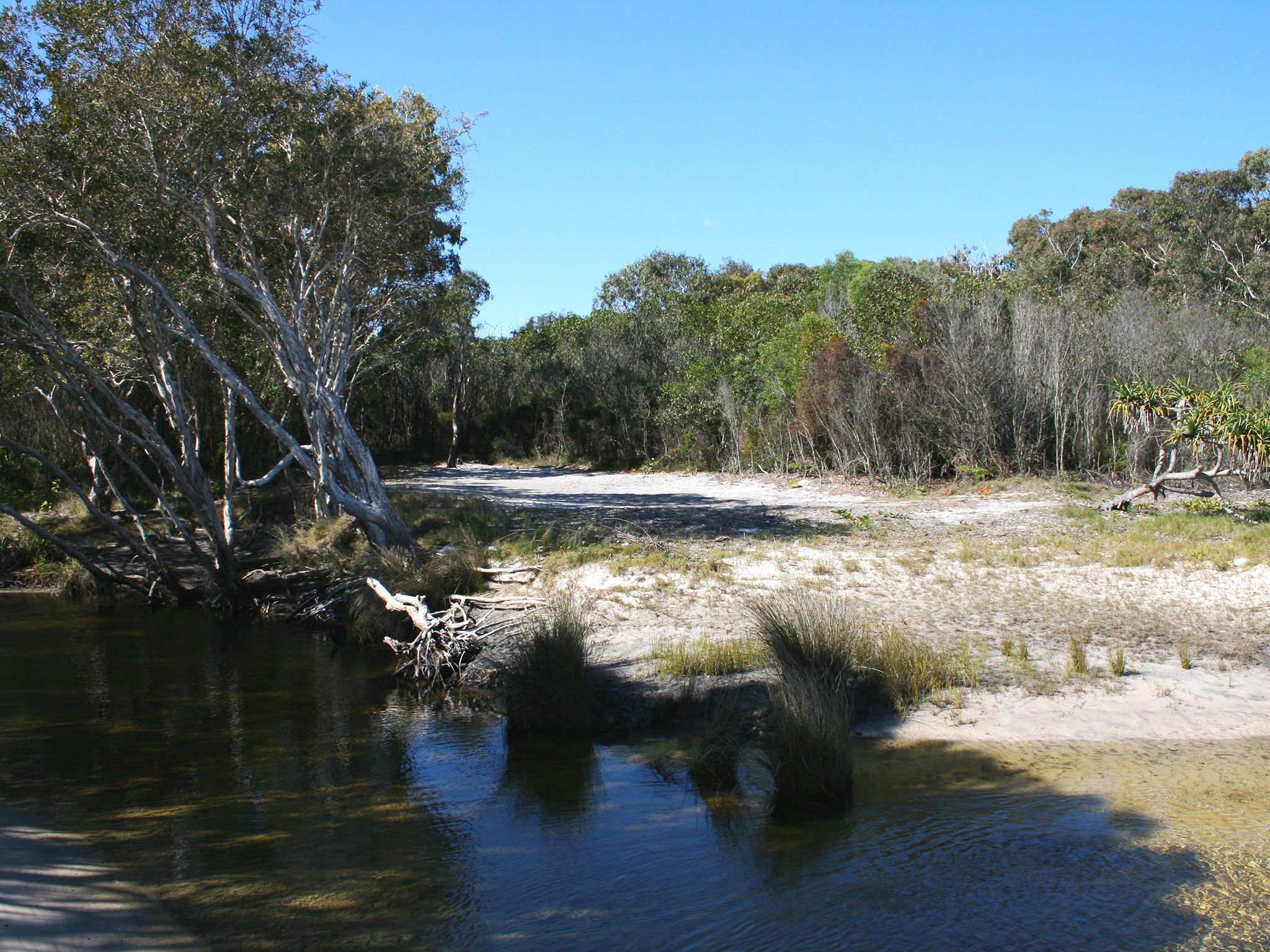
![Enjoy winter visits to this picturesque camping area.]() Enjoy winter visits to this picturesque camping area.
Photo credit: Jenna Tapply © Queensland Government
Enjoy winter visits to this picturesque camping area.
Photo credit: Jenna Tapply © Queensland Government
-
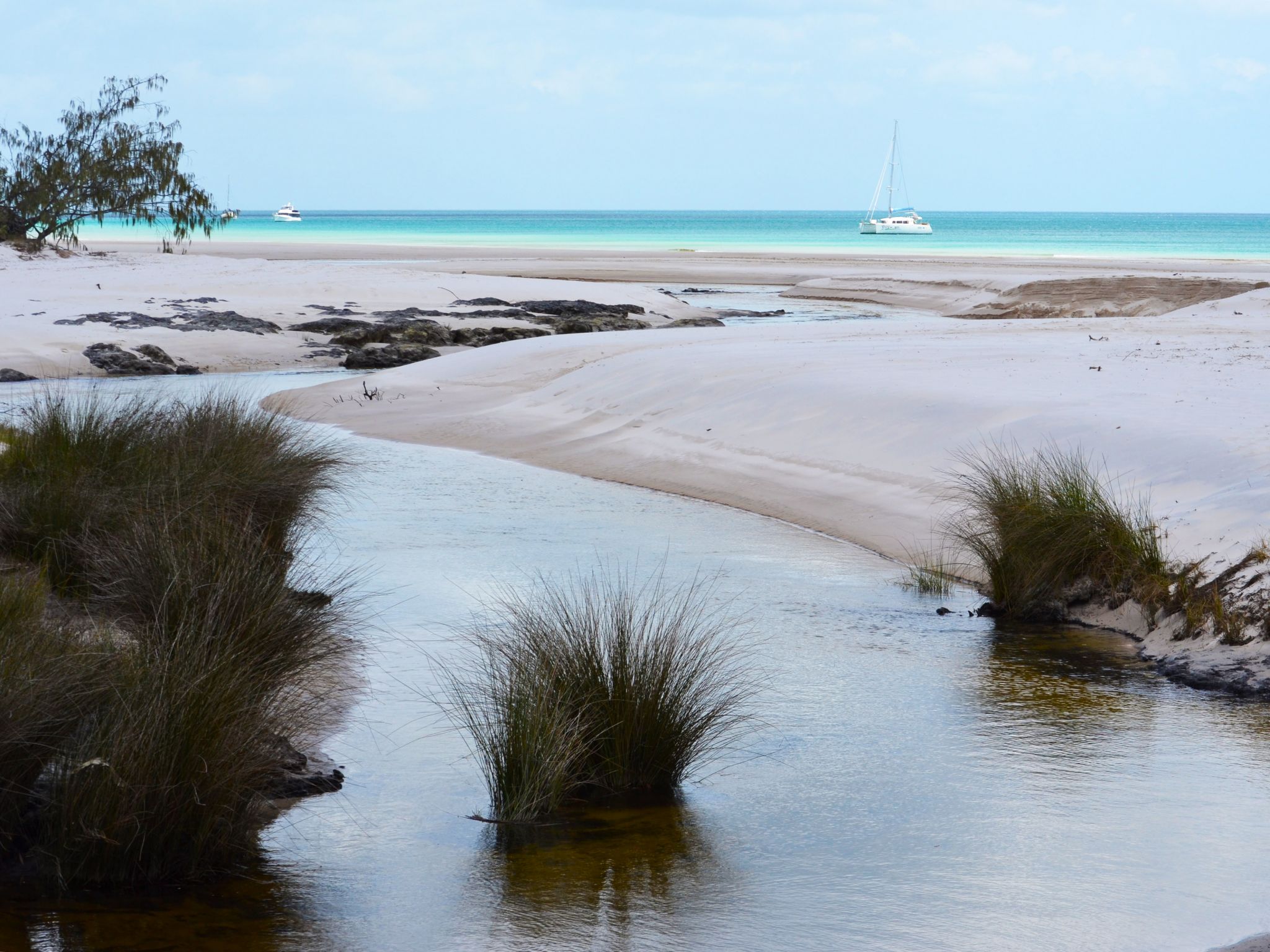
![Watch the creek carve its way through the sands of Kgari's western beach.]() Watch the creek carve its way through the sands of Kgari's western beach.
Photo credit: Rob Cameron © Queensland Government
Watch the creek carve its way through the sands of Kgari's western beach.
Photo credit: Rob Cameron © Queensland Government
Queensland National Parks Booking System Update
The new Queensland National Parks Booking Service is live for bookings.
Customer account login
If you are making your first booking since 1 July 2024, a new customer account will be created automatically as part of your next booking. Please note your previous login credentials will no longer be valid.
Customers who have made a booking after 1 July 2024, please use your email address to reset your password to access your account.
Always check
- Park alerts for the latest information on access, closures and conditions.
- Bureau of Meteorology weather forecasts.
- Current bushfire warnings and incidents and also fire bans and restrictions.
- Your camping permit is booked.
- Any park-specific camping information for
K'gari.
- Visiting K'gari safely for important safety information.
You’ll never want to leave this camping area, nestled in woodlands of white mahogany, eucalypts and wattles fringing a shallow freshwater creek.
At low tide explore the beach by 4WD, or slip your kayak into the sheltered water of Platypus Bay and explore the nearby coastline. Throw in a line from the beach and see if you can land a feed of fish for dinner.
If relaxation is more your style, settle into your camp chair with a good book. At night, you’ll be lulled to sleep by the gentle sounds of waves washing up the beach.
This park is part of the K'gari (Fraser Island) World Heritage Area, famed for its exceptional natural beauty, outstanding examples of coastal dune landform development and evolutionary history.
Getting there and getting around
Bowarrady Creek beach camping area is on K'gari, 15km off the coast of Hervey Bay and about 300km north of Brisbane.
- The camping area is 2.9km north of Woralie Road on the western beach, 19km north of the Moon Point estuary in Platypus Bay.
- It is accessible by boat via the Great Sandy Marine Park, and by vehicle along the beach at low tide. You will need to drive across Bowarrady Creek.
- The GPS location is Zone 56J, easting—513611 and northing—7223087.
- The map location is latitude S25˚06'29" and longitude E153˚08'06".
- The Western Beach is not suitable for trailers except for designated camper trailer sites in Woralie Creek beach camping area.
Getting to K’gari
You can get to the island by high clearance 4WD, on foot, by plane or with a commercial tour.
- Check the K’gari conditions report for the latest information on access, closures and conditions within the recreation area.
- Subscribe to the RSS feed to receive automated updates. (About RSS feeds).
By 4WD
- Your high clearance 4WD must have low range functions.
- Remember all vehicles must be registered, drivers must be licensed and all Queensland road rules apply, even on beaches.
- Read 4WD with care for important information on 4WD safety and minimal impact driving.
- A vehicle access permit must be purchased. Display the permit on your windscreen before driving in the recreation area.
From Inskip Point (15mins from Rainbow Beach)
- At the end of the bitumen on Inskip Point Road, reduce tyre pressure, engage 4WD and drive 500m onto the beach.
- Drive onto the Manta Ray barge for the 10–15min trip to Hook Point on the southern tip of K’gari, and the start of the Eastern Beach scenic drive.
- Bookings for this barge are not required.
From River Heads (east of Maryborough)
- Travel 10.6km along River Heads Road to the Barges landing area.
- The trip to Wanggoolba Creek on the western side of K’gari takes 30–45min.
- The trip to Kingfisher Bay on the western side of K’gari takes 50min–1hr.
- These barges run at fixed times and bookings are essential.
On foot
- Walkers can board a vehicle barge to the island (details above) or arrive by plane.
By plane
- Flights leave from Hervey Bay and Maryborough.
By private vessel
- Access K’gari’s sheltered western coastline by private vessel. The eastern coastline of the island is extremely hazardous and exposed to very rough ocean conditions.
- Launch your boat at one of the many boat ramps on the mainland between Tin Can Bay and Burnett Heads. There are no boat ramps on K’gari.
- See Maritime Safety Queensland’s Beacon to Beacon Guides for the Great Sandy Strait and Hervey Bay for detailed navigational maps.
- The waters adjacent to K’gari are in the Great Sandy Marine Park.
- If you’re heading out on the water make sure you know your zones so you can follow the rules.
- Read boat and fish with care for tips on boating and fishing safety and caring for parks.
Commercial tours
- You can join a range of tours that leave from a variety of centres.
- For tourism information for all regions in Queensland, see Queensland.com, and for friendly advice on how to get there, where to stay and what to do, find your closest accredited visitor information centre.
Before you visit
Opening hours
Bowarrady Creek camping area is open 24 hours a day. Check-in to your camp after 2pm and check-out by 11am on the day of departure.
Bookings
Book online or learn about our camping booking options. Advance bookings are required for holiday periods.
Book a camping area Book a vehicle access permit
Visiting safely
For more safety information see Visiting K'gari safely and camp with care.
- Beach camping zone 9 and access to Ngkala Rocks to Sandy Cape CLOSED 10 March to 31 May 2025
- Woralie Road Dump Ezy Temporary Closure 13 July 2023 to 5 August 2025
- Park Alert-Tukkee Wurroo (Indian Head) walking track temporary closure 14 June 2021 to 18 December 2025
- Large tides and ocean swell affecting beach driving 9–12 May 2025
- Severe weather damage affecting access at Yidney Rocks 23 April to 21 May 2025
- K'gari (Fraser Island Recreation Area) Road CLOSURES 21 March to 16 May 2025
- Eli Creek Exposed Sand Dunes 14 April to 28 May 2025
- K'gari Great Walk Partial Closures 22 April to 27 May 2025
- Heightened dingo activity Lake McKenzie (Boorangoora) 15 April to 30 June 2025
- Giant Satinay Walk Closure 14 April to 27 May 2025
- Jabiru Great Walk Access Track and Jabiru Hikers Camp Closure 31 March to 27 May 2025
- Dingo (Wongari) Seasonal Information - Mating Season 1 March to 31 May 2025
- Park Alert - K’gari Planned Burn Season 2025 26 February to 31 August 2025
- Poison canisters washing up on Southeast Queensland beaches 4 July 2024 to 30 June 2025
- Northern Forests scenic drive CLOSED, detour in place 4 June 2024 to 3 June 2025
- Northern Forests walking track CLOSED 4 June 2024 to 3 June 2025
- Beware crocodiles
- Be dingo-safe
- Beware marine stingers (jellyfish)
Conditions report
K'gari conditions report Updated 7 May 2025
Critical information for your safety is included in the conditions report—always check it before you visit.